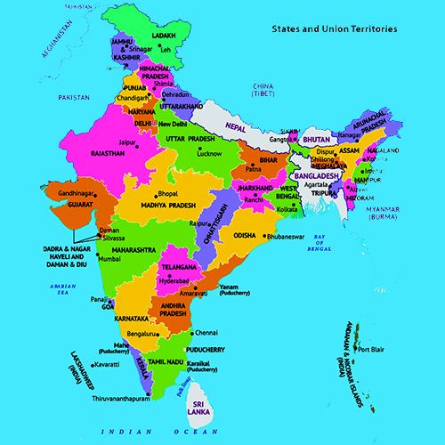
Lesson 1 : India-a beautiful Country![Lesson 1 : India-a beautiful Country]()
New Words we Found
Peninsula : A large area of land that is surrounded by water on three sides.
Plateau : An elevated large flat area.
Points to Remember
+ India is called a subcontinent because of its varied landforms, climates etc.
+ The southern part of India is a peninsula. It is surrounded by water on three sides.
+ Presently, India has 28 states and 9 union territories. Seven states of northeast India are together called the seven sisters.
+ Nepal, Bhutan, Myanmar, China, Bangladesh, Pakistan and Afghanistan are our neighbour Sri
states.
Tick [tikbox] the correct answer.
1. The southern part of our country is surrounded by the-
a. Arabian Ocean [box]
b. Indian Ocean [tikbox]
c. Pacific Ocean[box]
2. The land frontier of India is about-
a. 12,200 km long[box]
b. 18,200 km long [box]
c. 15,200 km long[tikbox]
3. India is also called a-
a. continent [box]
b. island [box]
c. subcontinent [tikbox]
4. The total length of the coastline of India is about-
a. 7,800 km [box]
b. 22,000 km [box]
c. 7,517 km [tikbox]
5. The smallest state of India is-
a. Goa [tikbox]
b. Tamil Nadu [box]
c. Kerala [box]
Fill in the blanks
1. India is the
7th largest country of the world.
2. The seven northeastern states of India are together called the
seven sisters3. India is located in the
southern part of Asia.
4. India presently has
8 union territories and
28 states.
5. The largest state of India is
Rajasthan.
Question and Answers
Why India called a subcontinent?
India is called a subcontinent because of its vastness, various landforms, climates, vegetation and Minerals etc.
Name any three Northeastern states of India.
Meghalaya, Mizoram and Manipur are the three north eastern states of India.
Name any five neighbours of India.
Nepal, China, Bhutan, Pakistan and Bangladesh are the five neighbours of India.
Which ocean is named after our country?
The Indian Ocean is named after our country.
What is the population of India?
The population of India is more than 1.3 billion people.
What is a Peninsula? Why is southern India A Peninsula?
Such a landform which is surrounded by water on three sides is called a Peninsula. The southern part of our country is a Peninsula as it is surrounded by the Indian ocean in the south, the Arabian Sea in the west and the Bay of Bengal in the East.
What are the main physical features of India?
The main physical features of India are…
The northern mountains.
The northern plains.
The Western desert or the great Indian desert
The southern plateau.
The coastal plains.
The island.
Describe the political divisions of India.
Our country is divided into 28 states and 8 union territories. New Delhi is the capital of our country.
What is a union territory? name all the union territories of India.
Union territory is a type of Administrative division in a country. The union territories of India are
i) Andaman and Nicobar Island.
ii) Chandigarh
iii) Delhi (National capital)
iv) Jammu and Kashmir
v) Lakshadweep
vi) Ladakh
vii) Puducherry
viii) Dadra and Nagar Haveli & Daman and Diu.
Difference between a Political map and a physical map.
The difference between a political map and a physical map is - a political map shows the political divisions of a country while a physical map shows the physical features of a country.


